Skip to Content
North Fork Mapping
Home
Shop Maps
Custom Maps
Stockists
Wholesale
About
FAQs
Artist Resources
Contact
Follow us on Instagram
Follow us on Facebook
0
0
North Fork Mapping
Home
Shop Maps
Custom Maps
Stockists
Wholesale
About
FAQs
Artist Resources
Contact
Follow us on Instagram
Follow us on Facebook
0
0
Home
Shop Maps
Custom Maps
Stockists
Wholesale
Folder: About
Back
FAQs
Artist Resources
Contact
Follow us on Instagram
Follow us on Facebook
Shop Maps West Highland Way - Scotland
WestHighlandWayMap_NorthForkMapping_Framed.jpg Image 1 of 6
WestHighlandWayMap_NorthForkMapping_Framed.jpg
WestHighlandWayMap_Screenshot.JPG Image 2 of 6
WestHighlandWayMap_Screenshot.JPG
WestHighlandWayMap_Screenshot2.JPG Image 3 of 6
WestHighlandWayMap_Screenshot2.JPG
Scotland_WestHighlandWay_allthethings_16x20-01.jpg Image 4 of 6
Scotland_WestHighlandWay_allthethings_16x20-01.jpg
Scotland_WestHighlandWay_basics_16x20-01.jpg Image 5 of 6
Scotland_WestHighlandWay_basics_16x20-01.jpg
Scotland_WestHighlandWay_min_16x20-01.jpg Image 6 of 6
Scotland_WestHighlandWay_min_16x20-01.jpg
WestHighlandWayMap_NorthForkMapping_Framed.jpg
WestHighlandWayMap_Screenshot.JPG
WestHighlandWayMap_Screenshot2.JPG
Scotland_WestHighlandWay_allthethings_16x20-01.jpg
Scotland_WestHighlandWay_basics_16x20-01.jpg
Scotland_WestHighlandWay_min_16x20-01.jpg

West Highland Way - Scotland

from $34.00

The first of our international maps! From Milngavie north of Glasgow to Fort William this map covers the West Highland Way, Scotland’s first designated Long Distance Route and one of Scotland’s Great Trails. If you want the most level of detail, we suggest the 16”x20” or 24”x30” sized maps.

See below for descriptions on our three signature styles.

Prints are shown framed for display purposes only.

Size:
Style:
Quantity:
Add West Highland Way Map to Cart

The first of our international maps! From Milngavie north of Glasgow to Fort William this map covers the West Highland Way, Scotland’s first designated Long Distance Route and one of Scotland’s Great Trails. If you want the most level of detail, we suggest the 16”x20” or 24”x30” sized maps.

See below for descriptions on our three signature styles.

Prints are shown framed for display purposes only.

West Highland Way Map!

We have three signature styles of map depending on what you’re looking for:

“Minimalist” - Title and topo lines as well as rivers, lochs, the ocean, and, of course, the West Highland Way trail. Clean, simple, elegant. More of an “art” look than a “map” look.

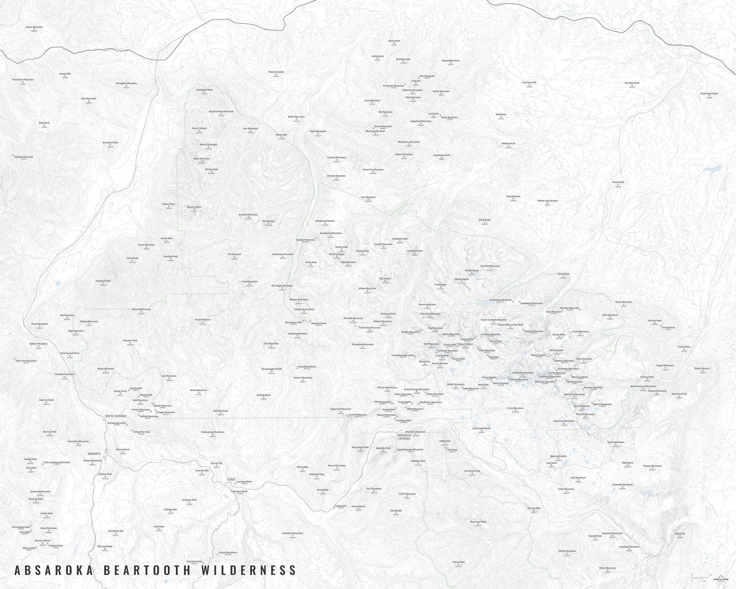
“Just The Basics” - Adding onto the minimalist style with summit names and elevations, roads, and a scale bar. A basic map.

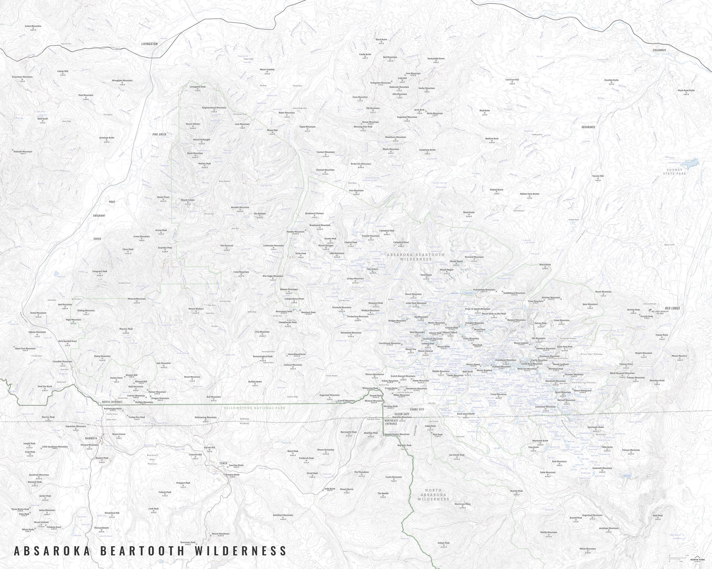
“All The Things” - Just as it sounds. The mappiest of them all. Adding forests, National Parks, the Jacobite Railway, towns, hydrology labels, and several common place names.

You Might Also Like

Yellowstone National Park IMG_4366.jpg IMG_4367.jpg IMG_4308.jpg IMG_4309.jpg Yellowstone_11x14_min-01.png Yellowstone_11x14_basics-01.png Yellowstone_11x14_all-01.png Yellowstone_11x11_min-01.png Yellowstone_11x11_basics-01.png Yellowstone_11x11_all-01.png
Yellowstone National Park
from $8.00
Continental Divide Trail continental_divide_trail_map_zoom.JPG ContinentalDivideTrail_Bas_NorthForkMapping.jpg ContinentalDivideTrail_Min_NorthForkMapping.jpg
Continental Divide Trail
from $34.00
Flathead Lake FlatheadLakeMap_NorthForkMapping.jpg FlatheadLakeMap_zoom.JPG FlatheadLakeMap_all_bath_11x17-01.jpg FlatheadLakeMap_bas_bath_11x17-01.jpg FlatheadLakeMap_min_bath_11x17-01.jpg FlatheadLakeMap_all_NObath_11x17-01.jpg FlatheadLakeMap_bas_NObath_11x17-01.jpg FlatheadLakeMap_min_NObath_11x17-01.jpg
Flathead Lake
from $34.00
Absaroka Beartooth Wilderness Map AbsarokaBeartoothMap_Screenshot2.JPG AbsarokaBeartooths_min_42x52-01.jpg AbsarokaBeartoothMap_Screenshot1.JPG AbsarokaBeartooths_basics_42x52-01.jpg AbsarokaBeartooths_all_42x52-01.jpg
Absaroka Beartooth Wilderness Map
$152.00
Shields River Valley ShieldsRiverValleyMap1.JPG ShieldsRiverValleyMap2.JPG ShieldsRiverValleyMap_AllTheThings-01.jpg ShieldsRiverValleyMap_JustTheBasics-01.jpg ShieldsRiverValleyMap_Minimalist-01.jpg
Shields River Valley
from $46.00

NORTH FORK MAPPING

COPYRIGHT © 2020-2025, NORTH FORK MAPPING, LLC

Frequently Asked Questions

Contact Us

NFM_Main logo b+w_smaller.jpg